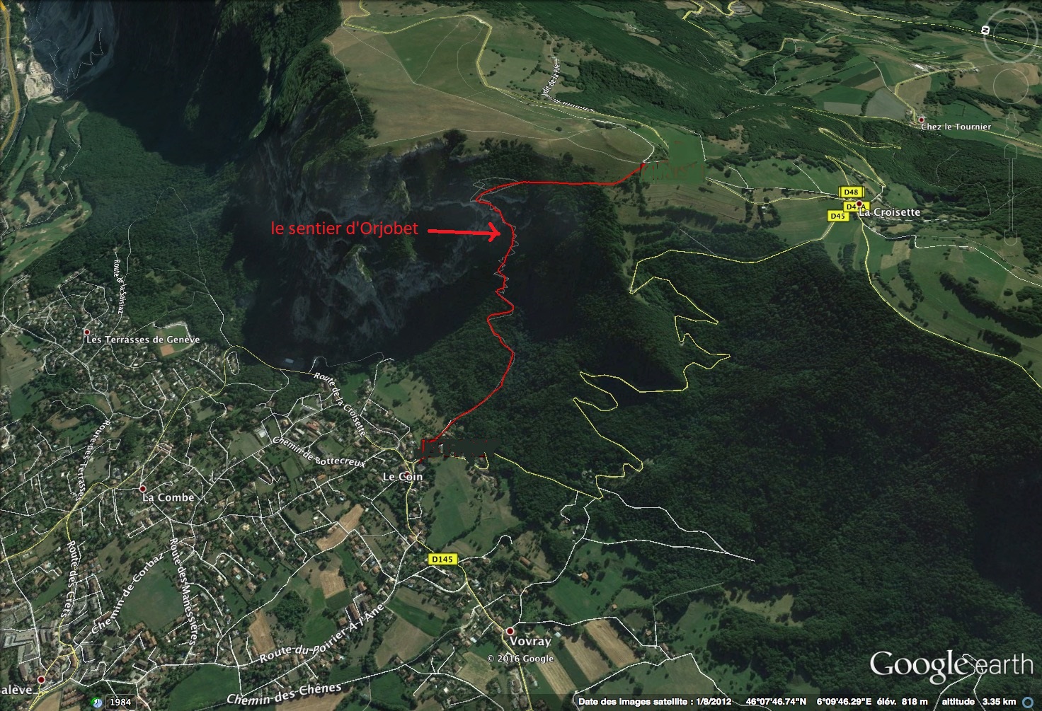
Après la douane de Veyrier (400 mètres d’altitude), traversez la D1206 (old N206), qui relie Annemasse à St-Julien, puis continuez la marche tout droit direction Salève. 200 mètres après la D1206 (old N206) franchissez la voie ferrée. Tournez à droite à 90° et marchez au longue de (parallel à) la voie ferrée sur presque un kilomètre puis traversez à gauche le pont sur l’autoroute A40 (Voir_Plan). Après le pont tournez à droite en marchant sur la route menant à Archamps sur 50 mètres (à votre gauche une muraille d'une hauteur de 140 centimètres) puis en tournant vers la gauche (entre la muraille et le pylône électrique) à 90° gravissez le talus et montez dans la forêt. 200 mètres plus loin vous arrivez à la carrière. Tournez à droite et après 100 mètres, à gauche, en bordure de la carrière. Cent mètres plus loin, au niveau du golf de Bossey, tournez à droite en contournant le golf par la gauche, passez à gauche de la cloture anti sangliers et montez jusqu’au sentier de base du Salève. Prenez ce sentier qui se dirige presque de niveau vers le sud-ouest à travers la forêt en direction de Collonges sous Salève, c.-à-d. à droite. Laissez successivement à droite deux chemins descendant vers Bossey, puis à gauche la sente de la Petite Gorge. Après un peu plus d’un kilomètre sur le plat (45 minutes depuis Veyrier) vous arrivez à un écriteau ("Sentier de la Grande Gorge - 610 m" :
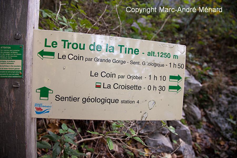
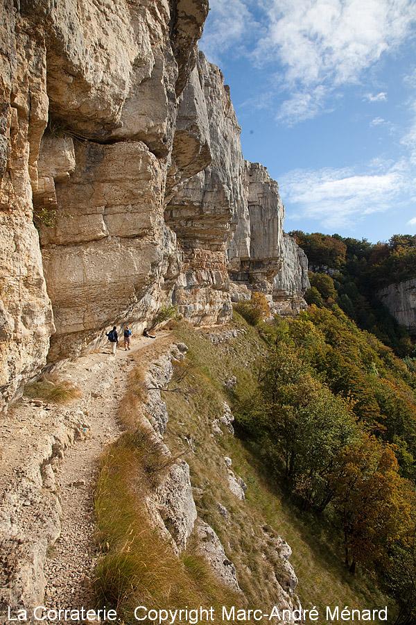
soit 1) aller à gauche (old pancarte , new pancarte ) pour visiter le Trou de la Tine et la Corraterie [10 minutes. La Corraterie (importantes voûtes rocheuses, passage aérien = un long passage sur un sentier flirtant avec le vide le long d’une vire à flanc de falaise) est déconseillé aux personnes sujets au vertige . A éviter par gros vent et JAMAIS en hiver (à cause de la glace). Si le vent vous "tombe dessus", baissez-vous, accrochez-vous aux rochers, avancez prudemment à 4 pattes]. Remarque concernant le vent: si vent, il y a danger d'une bourrasque = tourbillon de vent impétueux et de peu de durée = très dangereux car soudaine.
soit 2) aller tout droit pour aboutir à la route des Crêtes (D41) au carrefour de la Bouillette sur la crête du Salève (1214m) (15 minutes). Si vous optez pour le sentier très raide (B) vous prenez le sentier qui part vers la gauche c.-à-d. qui parte à gauche à 2 mètres à droite du poteau indicant "allez à droite" [il faut ignorer le poteau suivant (après une petite descente) indicant "allez à droite"] . Au bout de quelques centaines de mètres vous rejoignez le sentier d’Orjobet en 15 à 20 minutes.
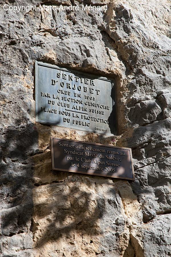
Description basée sur « Randonnées au Salève » , 53 itinéraires et une carte au 1:25’000, 7.1984, section genevoise du Club Alpin Suisse, Pierre Bossus.
plan des sentiers et animaux du Salève - pdf = pdf de 12 mega. Si page vide, clic sur download (fleche pointant vers le bas à droite la haut) puis Open with AARDC = Adobe Acrobat Reader.Voir aussi http://www.collonges.net
(Tourisme & culture et Les Sentiers),
http://randos-montblanc.com/pages/description/saleve.html ,
http://montagnes.topos.free.fr/topos/rando/saleve_orjobet.htm
,
http://www.bibiweb.ch/wordpress/?p=1848 (le blog de Brigitte Djajasasmita),
http://rochsnake.centerblog.net/rub-le-saleve-.html
L’Impartial du 8.8.2007 à la page 2 Source: http://www.arcinfo.ch/pdf/impartial/IMP_2007/08-2007/08082007.pdf - De Troinex à Veyrier par le Salève (textes et photos
Annick Monod).
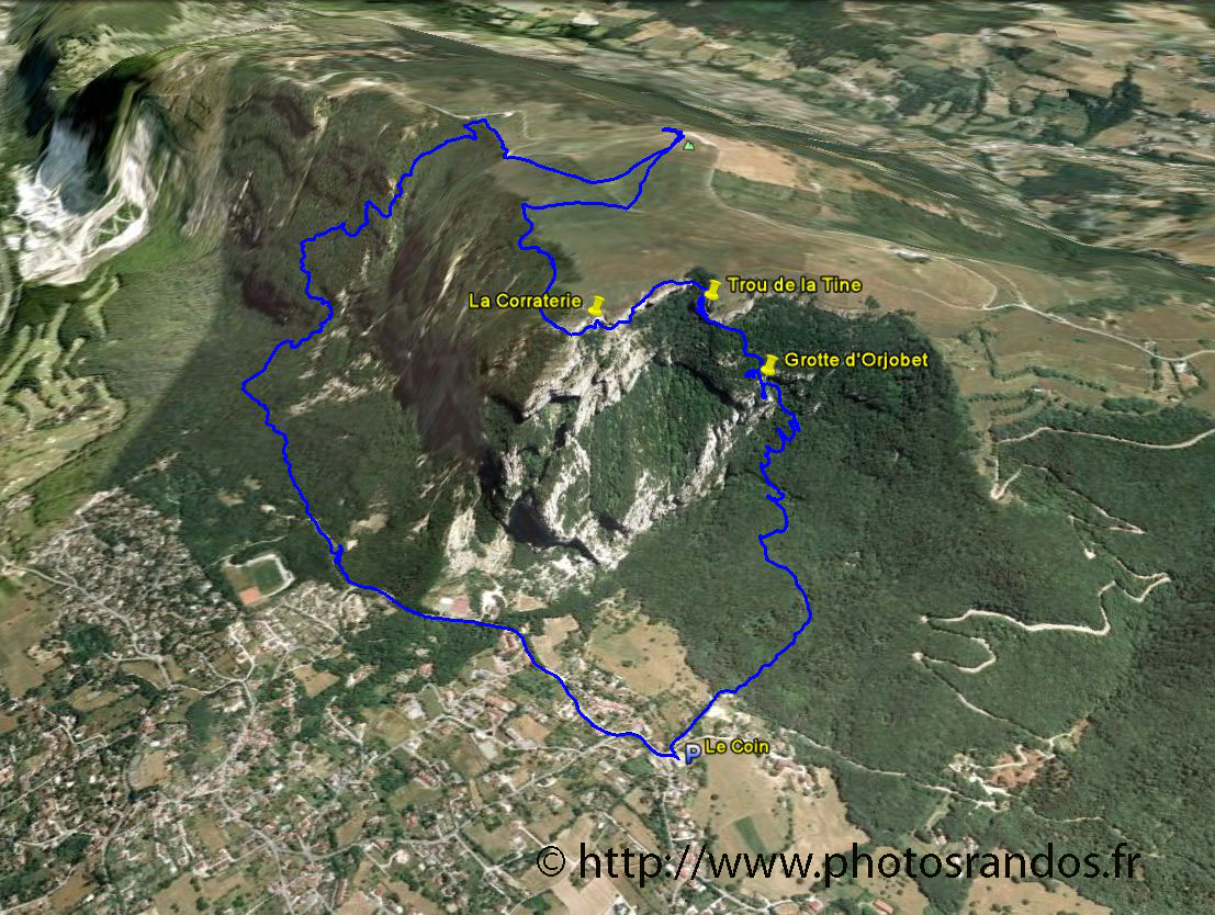
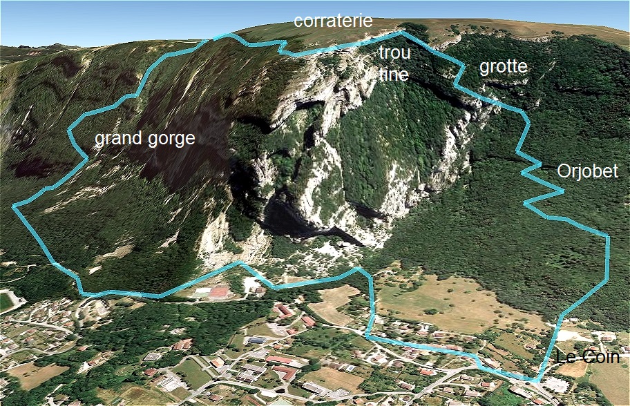
Départ de Collonges sous-Salève au lieu-dit "Le Coin" (666m), traversée au pied du Salève jusqu'à la cote 610m puis montée jusqu’au plateau (1250m). Visite de la table d'orientation au point de vue 360°. Retourner au sentier du "Balcon du Léman" qui passe par la "Corraterie", le "Trou de la Tine" et la "Grotte d'Orjobet".
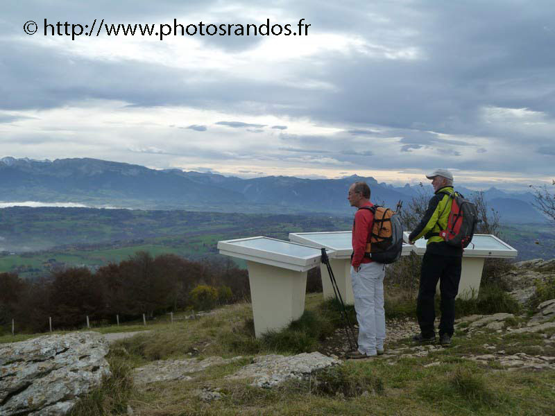
photo
http://www.geocaching.com/seek/cache_details.aspx?guid=314917f4-a65b-4348-9f2b-2999af95df42 = Le Coin - Grotte d'Orjobet - La Corraterie
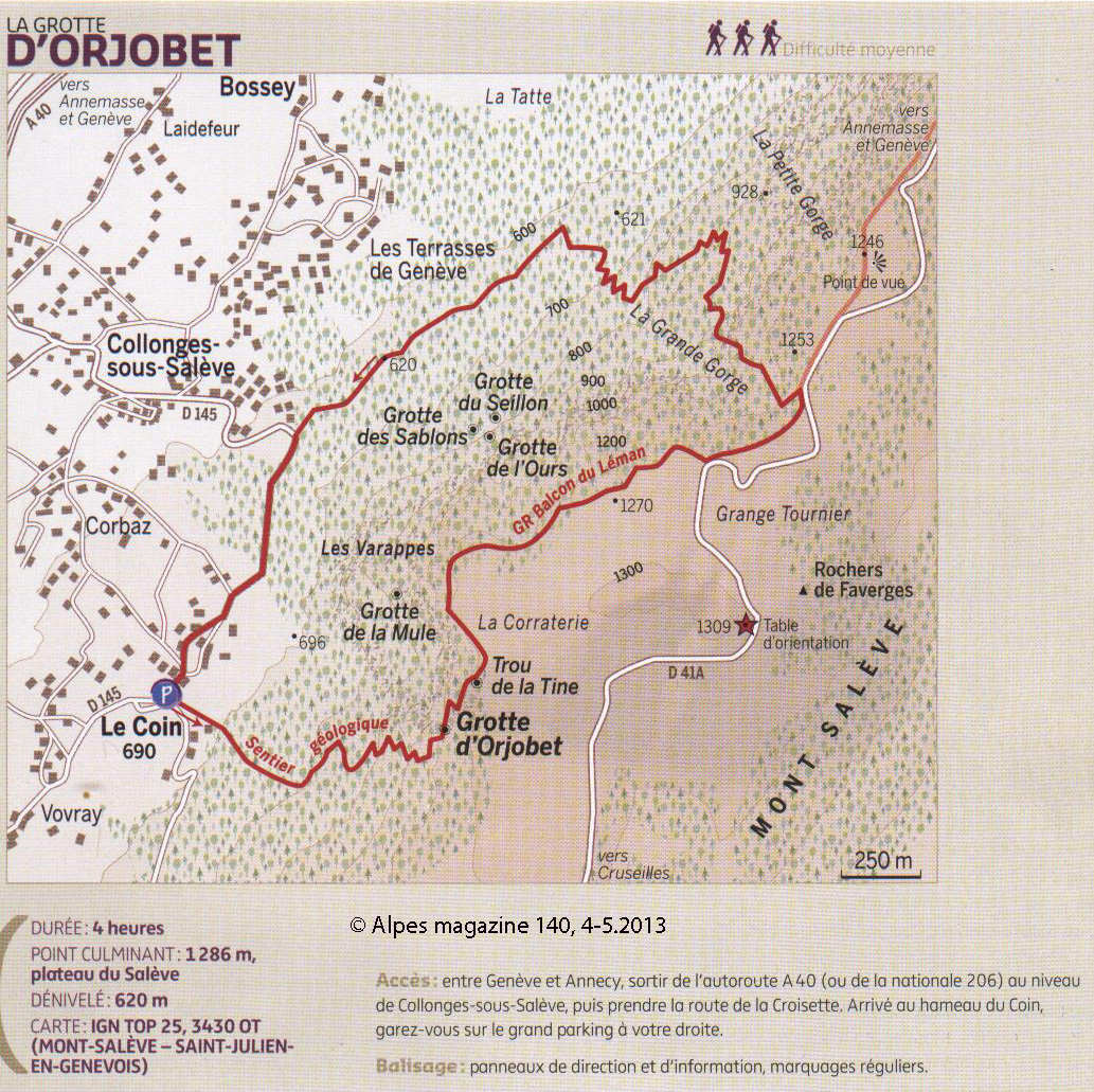
Extrait d’Alpes magazine 140, 4-5.2013
https://www.youtube.com/watch?v=J8WAKGwWc-U Vidéo 5 minutes = montée du sentier d'Orjobet.
http://www.visugpx.com/?i=1408197061
http://www.visorando.com/randonnee-le-saleve-par-le-sentier-d-orjobet/
http://www.randogps.net/randonnee-pedestre-gps-haute-savoie-74.php?num=99
Un circuit : Montée depuis Etrembières par Orjobet puis la Corraterie puis la station supérieure du téléphérique puis descente par Monnetier et le Pas de l'Echelle.
montée par Orjobet puis descente par la Grande Gorge (plan)
https://www.visugpx.com/oAwPmXHcko aboju le 04.01.2020, Salève 1292m - (Bornes) (Randonnée Pédestre) :
le Coin, Orj, la Corraterie, l’Observatoire, la GG, le Coin. 11Km, dénivélé 800m, 4 heures.
https://www.sitytrail.com/lang-en/t/18514 = Le Coin ^ Orjobet v Grande gorge – le Coin.
https://www.sitytrail.com/lang-en/t/668184 = Le Coin ^ Orjobet - Corraterie v Grande gorge – Le Coin.
https://www.sitytrail.com/lang-en/t/577706 = Le Coin ^ Orjobet - Corraterie ^ Rochers de Faverges v Grande gorge – Le Coin.
http://www.filmsdocumentaires.com/films/782-randonnees-leman-mont-blanc
Orjobet (0-2') et La Dent d'Oche (2-3'). Vidéo de Wolfgang Reipold, Switzerland, wolf@leman-mont-blanc.com et
http://www.dailymotion.com/video/x40pdwg durée vidéo 1'30 Le Salève par la Corraterie de Wolfgang Reipold, Switzerland,
wolf@leman-mont-blanc.com .
https://www.youtube.com/watch?v=PzW1pPVJYf0&feature=youtu.be
Vincent Libériste 21 avril 2016 : Croix de Savoie au Salève - durée vidéo 6'30
foto
le sentier d'Orjobet - pdf Texte et Photos: Alexander Zelenka, Terre et Nature 8.2.2018.
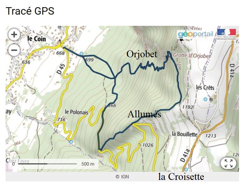
https://www.uneptiterando.com/saleve-sentier-orjobet-allumes
= départ et arrivée = le Coin, montée par le sentier d’Orjobet, descente par le Sentier des Allumés. foto parcours
https://www.savoie-mont-blanc.com/offre/fiche/sentier-geologique-de-la-grotte-d-orjobet/109118
https://www.youtube.com/watch?v=hv-FMKXh-Fs 1’ Climbing Salève le 26 sept. 2019 par Eric Hochwahr = Grotte d’Orjobet et la Corraterie.
http://www.lemanbleu.ch/fr/News/Balade-sur-les-cretes-du-Saleve.html
vidéo de 3’ avec Robert Klein. 11 octobre 2019 = Balade sur les crêtes du Salève depuis la Bouillette (1214m, 800 m au nord de la Croisette).
https://www.cirkwi.com/fr/circuit/137351-sentier-geologique-de-la-grotte-d-orjobet?
sentier géologique.
orjobterretnature - pdf "accessibles à tous les marcheurs" = faux. "difficil d'accéder autrement qu'en voiture" = faux
(à pied : depuis Veyrier = 1h30, depuis Croix de Rozon = 40').
Description of the Orjobet trail, leaving from Veyrier
After the customs in Veyrier (altitude 400 meters) go towards the mountain.
Cross the D1206 (old N206) (Annemasse - St-Julien) and 200 meters after, cross the railway.
Turn to the right and hike parallel to the railway for about one kilometer.
Cross, on your left, the bridge over the autoroute A40. After the bridge turn
to the right, direction Archamps, and after 50 meters turn to the left and hike
up the mountain entering the forest. After about 200 meters you will reach a
stone-pit (= quarry, carrières) . Turn to the right and after 100 meters go to the left along the border
of the stone-pit. After 100 meters turn to the right to reach the golf level, the protection against
the wild boars, turn to the left to contourne the golf from the left. Hike up left to join the path along the foot of the
Salève. Follow it direction Collonges sous Salève, i.e. right
,on a little bit more than one kilometer till you reach the signboard [ "Sentier
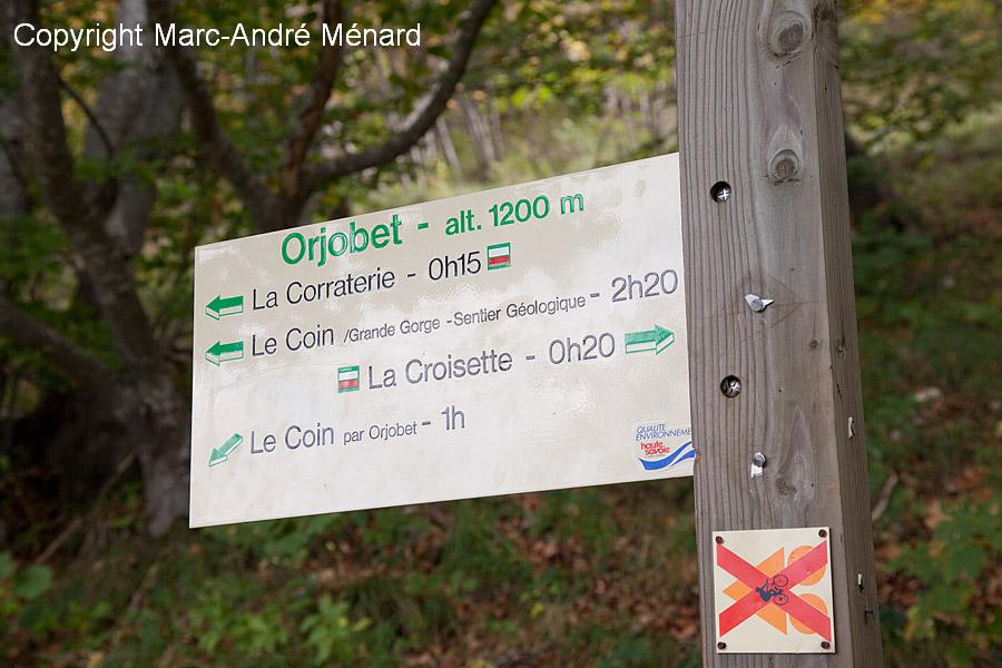
de la Grande Gorge - 610 m" :![]() Observatoire
2h10’,
Observatoire
2h10’,![]() Corraterie par la
Grande Gorge 2h30’ , Circuit géologique 40’
Corraterie par la
Grande Gorge 2h30’ , Circuit géologique 40’![]() ,
Collonges s/S 40’
,
Collonges s/S 40’![]() ,
,![]() Bossey
20’ ](45 minutes from Veyrier). Continue to hike horizontaly direction
Collonges sous Salève. After a little bit more than one kilometer you
will reach the tennis courts (see plan). Turn to
the left 90° and contourne the courts from the left. You will reach a water
tank between the « Refuge du Salève » and « Les Varrapes
» . Go towards the forest. Enter the forest. About 200 meters further,
coming out of the forest, you will see in front of you a garage and on his right
a house (Sentes + Rocs). Here you have 2 posibilities: A) less steep slope but
longer or B) very steep slope and shorter (the difference is 10 minutes). If you chose the less steep slope
(A), you take the road on your right for about 100 meters then turn to the left
and across a field. 300 meters further you reach an information table, situated
slightly higher and about 100 meters from the car park of the Coin (666m, one
and a half hour from Veyrier). Turn left and enter the forest. The path goes
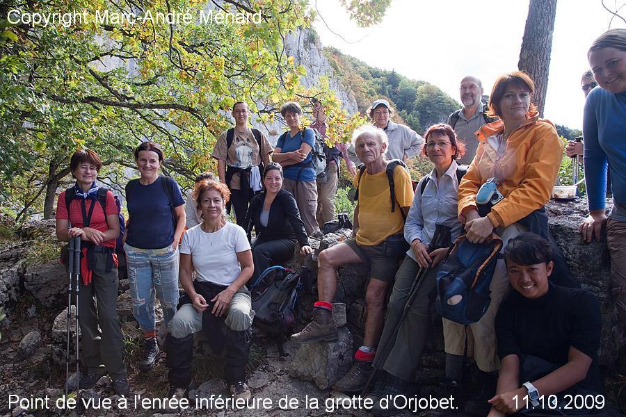
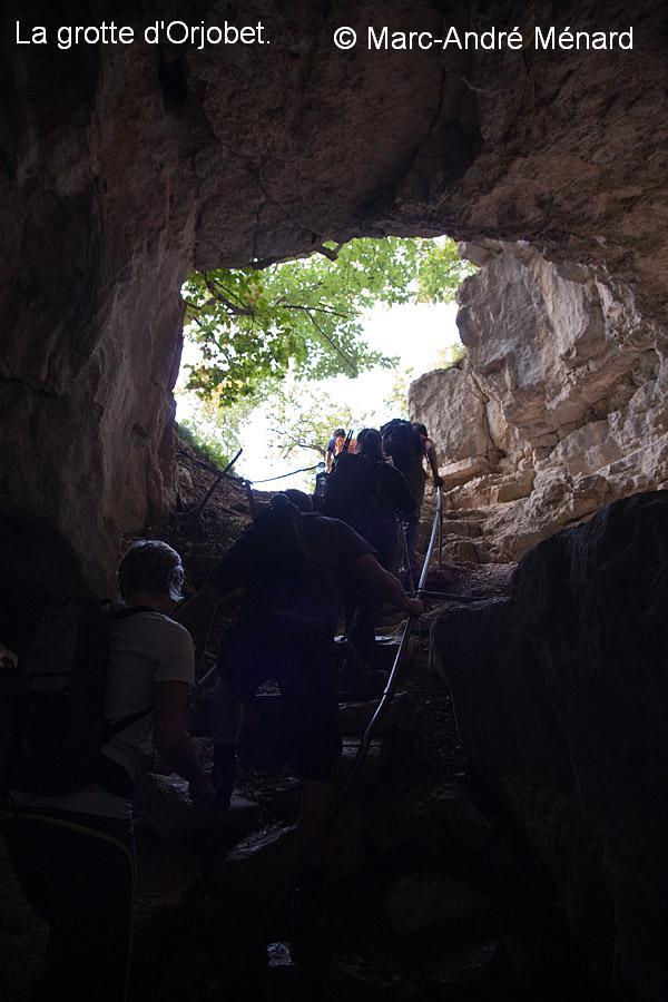
up in many zigzags. One hour later you arrive at the Grotto
d’Orjobet
where there are ladders and a cable to help you; this is at 1100m. Go through
it. 200 meters further you have 2 possibilities: 1) Tourning to your left (a direction sign) to
join the « Trou de la Tine » and the « Corraterie »
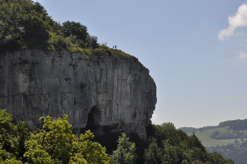
in about 10 minutes (the "Corraterie" is on a rocky shelf overlooking
Geneva. The path is narrow and exposed. Avoid it if there is a strong wind. If the
wind catches you, bend yourself and advance in that manner, not recommended for people with vertigo. NEVER in winter (because of the ice). or 2) continu straight and acces, in
15 minutes, the road on the ridge of the Salève (D41) at the cross-roads
of « la Bouillette » (1214m). If you chose the very steep slope
(B) you turn to the left. Few hundred meters later you will join the Orjobet
trail in about 15 to 20 minutes.
Bossey
20’ ](45 minutes from Veyrier). Continue to hike horizontaly direction
Collonges sous Salève. After a little bit more than one kilometer you
will reach the tennis courts (see plan). Turn to
the left 90° and contourne the courts from the left. You will reach a water
tank between the « Refuge du Salève » and « Les Varrapes
» . Go towards the forest. Enter the forest. About 200 meters further,
coming out of the forest, you will see in front of you a garage and on his right
a house (Sentes + Rocs). Here you have 2 posibilities: A) less steep slope but
longer or B) very steep slope and shorter (the difference is 10 minutes). If you chose the less steep slope
(A), you take the road on your right for about 100 meters then turn to the left
and across a field. 300 meters further you reach an information table, situated
slightly higher and about 100 meters from the car park of the Coin (666m, one
and a half hour from Veyrier). Turn left and enter the forest. The path goes
up in many zigzags. One hour later you arrive at the Grotto
d’Orjobet
where there are ladders and a cable to help you; this is at 1100m. Go through
it. 200 meters further you have 2 possibilities: 1) Tourning to your left (a direction sign) to
join the « Trou de la Tine » and the « Corraterie »
in about 10 minutes (the "Corraterie" is on a rocky shelf overlooking
Geneva. The path is narrow and exposed. Avoid it if there is a strong wind. If the
wind catches you, bend yourself and advance in that manner, not recommended for people with vertigo. NEVER in winter (because of the ice). or 2) continu straight and acces, in
15 minutes, the road on the ridge of the Salève (D41) at the cross-roads
of « la Bouillette » (1214m). If you chose the very steep slope
(B) you turn to the left. Few hundred meters later you will join the Orjobet
trail in about 15 to 20 minutes.
-o00o-